Send an enquiry

    Privacy Policy

    Services

    From strategy to delivery, our experts support complex challenges across the entire lifecycle of a project.

    • Environment
    • Engineering
    • Planning Consultancy
    • Safety
    • Sustainability Consulting
    • Net Zero and Decarbonisation
    • Energy & Decarbonisation
    Arboriculture & Forestry Consultancy Services
    Acoustics, Noise & Vibration Consultants
    Air Quality 2
    Air Quality Assessment Services
    Indoor Air Quality Assessment Services
    View All Air Quality
    Archaeology & Heritage
    Contaminated Land & Remediation
    Ecology & Biodiversity
    Environmental Impact Assessment
    Construction Environmental Management
    Environmental Permitting
    Flood Risk
    Glint & Glare
    Shadow Flicker Risk Assessment
    Hydrology & Hydrogeology
    Landscape & Visual
    Waste
    Soils & Peat
    Explore Environment
    Civil Engineering Consultants
    Structural Engineering
    Geotechnical Engineering
    Temporary & Enabling Works
    Process Engineering
    Energy Engineering
    Energy Analysis
    Environmental Engineering
    Water & Wastewater
    Surveying
    Asset Integrity
    Explore Engineering
    Planning Consultancy
    Transport Planning
    Explore Planning Consultancy
    Process Safety Consultants
    COMAH Compliance Consultants
    DSEAR & ATEX Compliance Services
    HAZOP Consultancy
    Machinery Safety
    Process Safety Training Consultants
    Health & Safety
    Occupational Hygiene Consultants
    Construction Design & Management (CDM)
    Explore Safety
    Environmental, Health & Safety (EHS) Legal Compliance Management
    ISO Management Systems Services
    Environmental, Social, Governance (ESG)
    Sustainability Programme Delivery Support
    Sustainability Skills and Training
    Explore Sustainability Consulting
    Product Carbon Footprint Consultants
    Buildings & Infrastructure Carbon Footprint & Reduction
    Carbon Verification & Assurance
    Industrial & Commercial Energy Solutions
    Public Sector Decarbonisation Solutions
    Net Zero Strategy & Climate Transition Plans
    Net Zero and Decarbonisation Training
    Carbon Footprint & Reporting
    Explore Net Zero and Decarbonisation
    Energy Generation Feasibility Design
    Energy Saving Opportunity Scheme (ESOS) Consultants 3
    Energy Saving Opportunity Scheme (ESOS)
    ESOS Phase 4 Compliance Consultants
    ESOS Action Plans
    View All Energy Saving Opportunity Scheme (ESOS) Consultants
    Explore Energy & Decarbonisation
    Request a Quote

    careers@arthian.com

    +44 (0) 3301 200 151

    • Office Locations
    • Resources
    Request a Quote
    • Services
      • Public Sector
    • Sectors
    • Projects
    • About Us
    • Training
    • Careers
    • Insights
    • Contact Us

    Services

    • Environment
    • Engineering
    • Planning Consultancy
    • Safety
    • Sustainability Consulting
    • Net Zero and Decarbonisation
    • Energy & Decarbonisation

    Environment

    • Arboriculture & Forestry Consultancy Services
    • Acoustics, Noise & Vibration Consultants
    • Air Quality
    • Archaeology & Heritage
    • Contaminated Land & Remediation
    • Ecology & Biodiversity
    • Environmental Impact Assessment
    • Construction Environmental Management
    • Environmental Permitting
    • Flood Risk
    • Glint & Glare
    • Hydrology & Hydrogeology
    • Landscape & Visual
    • Soils & Peat
    • Waste
    • Shadow Flicker Risk Assessment

    Engineering

    • Structural Engineering
    • Geotechnical Engineering
    • Temporary & Enabling Works
    • Process Engineering
    • Energy Engineering
    • Energy Analysis
    • Environmental Engineering
    • Water & Wastewater
    • Surveying
    • Asset Integrity
    • Civil & Structural Engineering
    • Civil Engineering Consultants
    • Flood Risk (FRA’s)
    • Drainage & SuDS
    • Bund Inspection, Assessment & Design
    • Integrated Nearshore, Landfall & Onshore Cabling Civil Engineering

    Planning Consultancy

    • Planning Consultancy
    • Transport Planning

    Safety

    • Health & Safety
    • Occupational Hygiene Consultants
    • Construction Design & Management (CDM)
    • Process Safety Consultants
    • Process Safety Training Consultants
    • COMAH Compliance Consultants
    • DSEAR & ATEX Compliance Services
    • HAZOP Consultancy
    • Machinery Safety

    Sustainability Consulting

    • Sustainability Skills and Training
    • Energy Compliance
    • ISO Management Systems Services 2
      ISO 14001
      ISO 50001
      View All ISO Management Systems Services
    • Sustainability Strategy, Reporting and Verification
    • Environmental, Social, Governance (ESG) 6
      Climate Risks & Resilience Assessment
      Corporate Sustainability Reporting Directive (CSRD)
      Double materiality assessment
      ESG Programme Alignment
      Social Value Consultancy
      UN Sustainability Development Goals (UN SDGs)
      View All Environmental, Social, Governance (ESG)
    • Sustainability Programme Delivery Support
    • Environmental, Health & Safety (EHS) Legal Compliance Management

    Net Zero and Decarbonisation

    • Net Zero and Decarbonisation Training
    • Product Carbon Footprint Consultants 4
      Lifecyle Assessment (LCA)
      Environmental Product Declarations (EPDs)
      Carbon Border Adjustment Mechanism Regulations (CBAM)
      Embodied Carbon Assessment (ECA)
      View All Product Carbon Footprint Consultants
    • Buildings & Infrastructure Carbon Footprint & Reduction
    • Carbon Verification & Assurance 1
      Airport Carbon Accreditation (ACA)
      View All Carbon Verification & Assurance
    • Net Zero Strategy & Climate Transition Plans
    • Carbon Footprint & Reporting
    • Public Sector Decarbonisation Solutions
    • Industrial & Commercial Energy Solutions
    • GHG Verification & Assurance

    Energy & Decarbonisation

    • Energy Saving Opportunity Scheme (ESOS) Consultants 3
      ESOS Phase 4 Compliance Consultants
      ESOS Action Plans
      Energy Saving Opportunity Scheme (ESOS)
      View All Energy Saving Opportunity Scheme (ESOS) Consultants
    • Energy Generation Feasibility Design
    • Services
      • Public Sector
    • Sectors
    • Projects
    • About Us
    • Training
    • Careers
    • Insights
    • Contact Us

    • Office Locations
    • Resources

    hello@arthian.com

    +44 (0) 3301 200 151

    Mobile Mapping
    Home | Services | Surveying | Mobile Mapping

    Mobile Mapping

    Fast, Safe & Accurate Data Capture for Roads, Infrastructure & Asset Management

    View All Surveying Services
    mobile-mapping

    Road Mapping, Asset Data & Route Condition

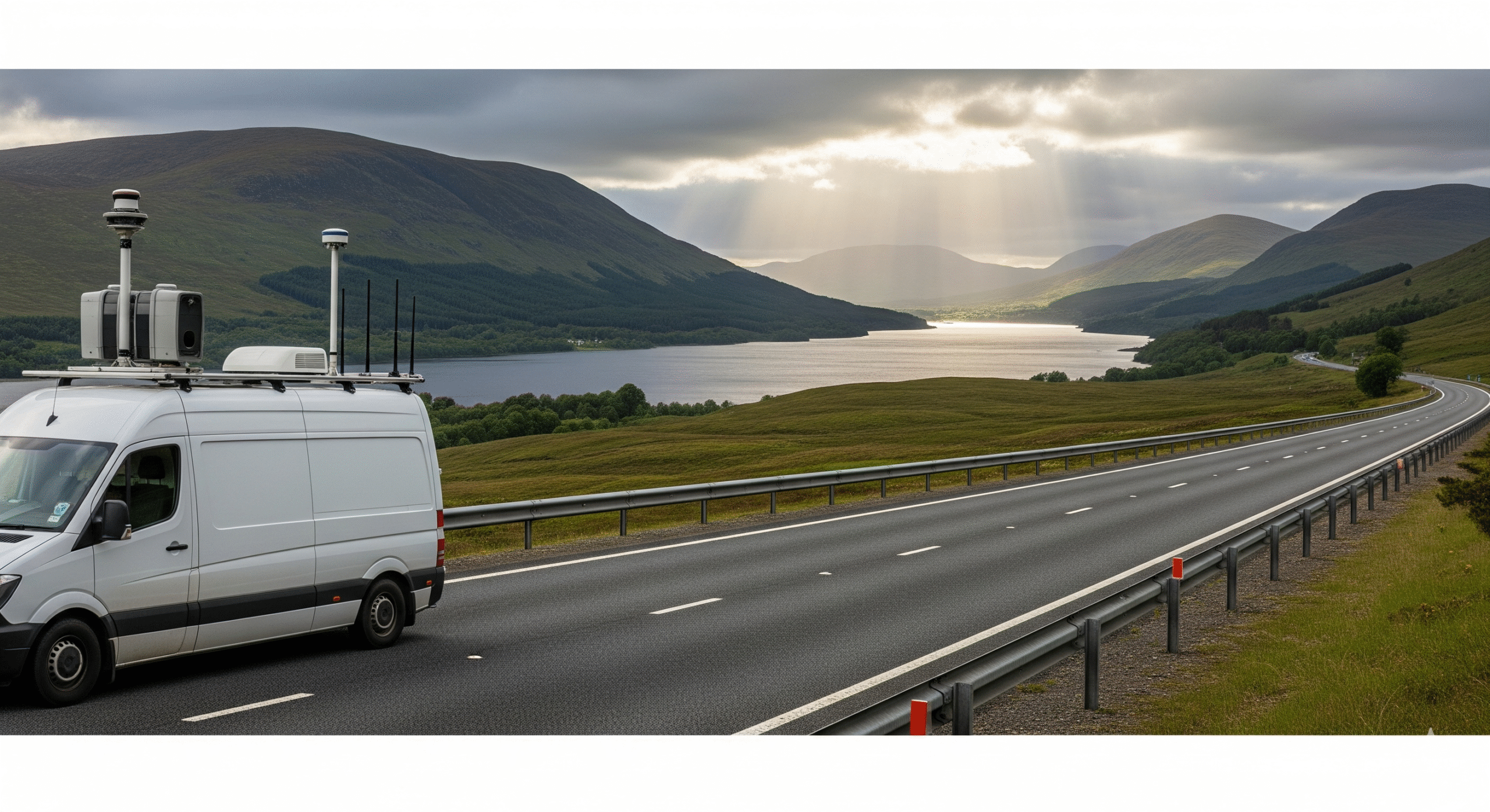
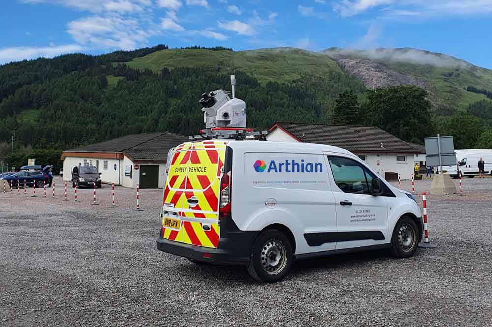
    Arthian delivers high-efficiency mobile mapping surveys for transport corridors, industrial estates and large geographic areas across the UK. Using vehicle-mounted LiDAR, GNSS and panoramic imaging systems, we capture engineering-grade spatial data at speed—reducing site time, safety risk and cost.

    Mobile Mapping for the Modern World

    We work with clients including BEAR Scotland to support transport route planning and maintenance programmes. Our mobile mapping outputs help identify asset condition, infrastructure degradation and priority areas for intervention.

    Our Services:

    Our mobile mapping services include:

    Applications
    Survey Methods & Technologies
    Deliverables
    Benefits of Mobile Mapping
    mobile-mapping

    Applications

    • Road and highway mapping
    • Verge, fencing and signage capture
    • Road surface condition and degradation monitoring
    • Emergency access and COMAH infrastructure planning
    • GIS and asset management integration
    mobile-mapping

    Survey Methods & Technologies

    • Vehicle-mounted LiDAR scanning
    • GNSS positioning and inertial navigation
    • Multi-camera panoramic imaging
    • 360° video and photogrammetry
    • GIS and CAD-ready data formats
    • UAV and terrestrial integration for hybrid datasets
    mobile-mapping

    Deliverables

    • Georeferenced point clouds
    • 2D and 3D CAD drawings
    • GIS asset inventories
    • Digital terrain models (DTM)
    • Orthomosaics and fly-through animations
    • BIM-ready outputs and visualisations
    mobile-mapping

    Benefits of Mobile Mapping

    • Rapid data capture over long distances
    • No need for traffic management or lane closures
    • Safer data collection from within the survey vehicle
    • High-volume data capture for linear infrastructure
    • Supports asset condition monitoring and maintenance planning


    mobile-mapping

    Applications

    • Road and highway mapping
    • Verge, fencing and signage capture
    • Road surface condition and degradation monitoring
    • Emergency access and COMAH infrastructure planning
    • GIS and asset management integration
    mobile-mapping

    Survey Methods & Technologies

    • Vehicle-mounted LiDAR scanning
    • GNSS positioning and inertial navigation
    • Multi-camera panoramic imaging
    • 360° video and photogrammetry
    • GIS and CAD-ready data formats
    • UAV and terrestrial integration for hybrid datasets
    mobile-mapping

    Deliverables

    • Georeferenced point clouds
    • 2D and 3D CAD drawings
    • GIS asset inventories
    • Digital terrain models (DTM)
    • Orthomosaics and fly-through animations
    • BIM-ready outputs and visualisations
    mobile-mapping

    Benefits of Mobile Mapping

    • Rapid data capture over long distances
    • No need for traffic management or lane closures
    • Safer data collection from within the survey vehicle
    • High-volume data capture for linear infrastructure
    • Supports asset condition monitoring and maintenance planning


    Why Choose Arthian's Surveying team?

    Engineering services delivered by specialists:

    Integration

    Fully integrated with geotechnical, hydrological, and ecological disciplines.

    Our Experience

    National experience with regional insight and regulatory familiarity.

    Our Understanding

    Deep understanding of planning, infrastructure, and environmental interfaces.

    Results Driven

    Commitment to technical rigour, clear communication, and long-term outcomes.

    Frequently Asked Questions

    What is mobile mapping?

    Mobile mapping is the process of collecting spatial data from a moving vehicle using LiDAR, GNSS and imaging systems. It’s ideal for surveying roads, railways and large sites quickly and safely.

    Can you capture roadside assets like signage and fencing?

    Yes—our systems detect and geolocate roadside features including signage, barriers, fencing, verges and street furniture. This supports asset inventories and maintenance planning.

    Can mobile mapping be used for route condition monitoring?

    Absolutely. We capture surface condition, degradation and change detection to support transport maintenance programmes and prioritisation.

    Do you provide GIS and BIM integration?

    Yes—we deliver GIS-ready datasets and BIM-compatible models to support planning, design and digital asset management.

    Get in Touch

    We’d love to hear from you – whether you have a question, a project in mind, want to explore job opportunities, or just want to say hello.

    Contact Us
    Arthian Logo

    Arthian is a trusted partner, working collaboratively to deliver client-focused solutions.

    Join our newsletter

      hello@arthian.com
      +44 (0) 3301 200 151

      Office Locations

      • England
      • Ireland & Northern Ireland
      • Scotland
      • Wales
      Back to Top
      • Policies
      • HTML Sitemap

      LinkedIn

      © 2025 Arthian Ltd. All Rights Reserved | The name Arthian and the Arthian logo are Trade Marks licensed to Arthian Ltd. | 13 Henderson Road, Inverness, IV1 1SN. Registered in Scotland No. SC 163378

      Design & Build by Atomic Digital Marketing